K-water Report
World’s First Satellite Exclusive for Water Resources
Management Opens a New Era of Water Management
K-water is accelerating the development of the world’s first satellite dedicated to water resources management in order to cope with water disasters effectively in the era of climate crisis. To this end, K-water is working on creating a cutting-edge observation system to open a new space era of water management.
Text by Editorial Team
Sources: Water Resources Satellite Center, Water Resources & Enviromental Research Center, K-water
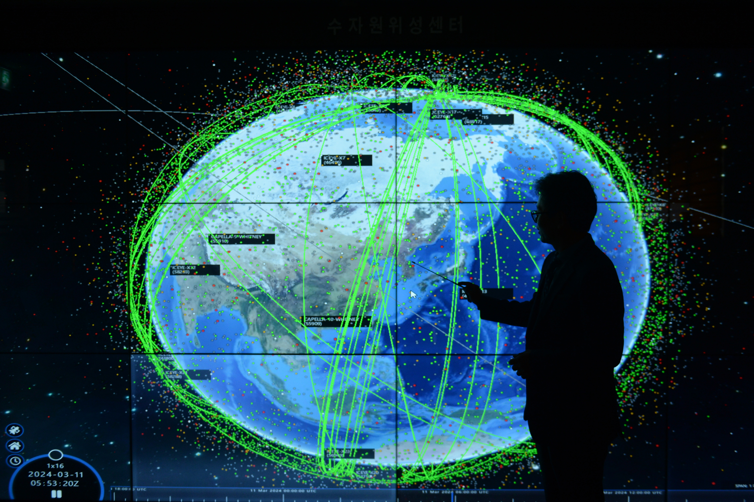
Water Resources Management Satellite and Future Weather Forecasting System
Extreme weather events are occurring more frequently than before. Recently, Brazil was hit by the heaviest rainfall in 80 years, recording a huge death toll; meanwhile, on the other side of the globe, Southeast Asia is suffering from extreme droughts. Global warming is causing heavier rains and more severe floods in a growing number of regions in the world while other parts of the world are struck by more intense droughts.
It is becoming increasingly difficult to predict the weather as climate variability continues to increase. In this context, it is necessary to develop a more accurate water disaster forecasting system and prepare for water disasters more effectively. The Ministry of Environment and K-water are working together to develop the world’s first water resources management satellite (Compact Advanced Satellite 5) in order to respond better to water disasters including floods and droughts. The development of the satellite began in 2016 when North Korea opened the floodgates along Imjin River without prior notice, flooding areas near the inter-Korean border. As the areas remain vulnerable to repeated floods, it is necessary to monitor water flows in rivers and streams across the entire Korean Peninsula on a real-time basis, and using a monitoring satellite has emerged as a new solution. With the use of a satellite, it will be easier to collect water flow data on tributaries and branches that are otherwise difficult for people to access and prepare for floods in a more timely manner.
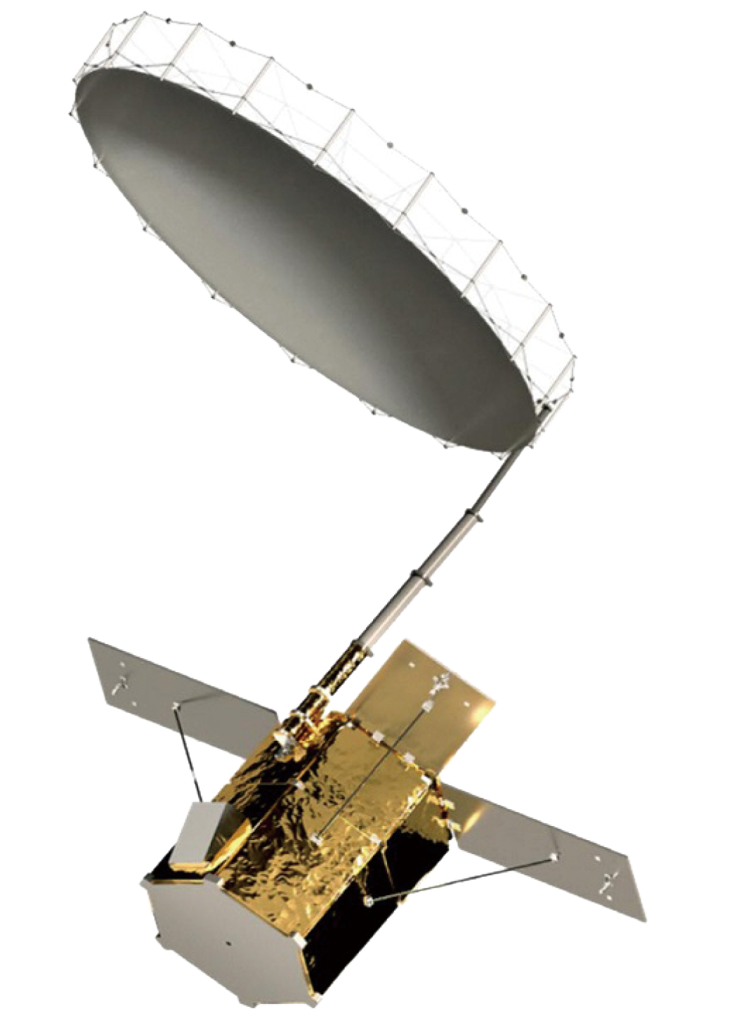
The Ministry of Environment and K-water has invested KRW 150.9 billion since 2022 in the development of a water resources management satellite that will be used to provide location-based flood forecasting, predict droughts, and monitor algal blooms as well as erosions and changes to dams, embankments, and other water infrastructure. NASA, European Space Agency (ESA), and Japanese Aerospace Exploration Agency (JAXA) are currently operating satellites to cope with climate change but not one of them is used exclusively for water resources management. If developed, it will be the first satellite dedicated to water resources management and water disaster monitoring. The 500kg satellite will be equipped with C-band SAR. Synthetic Aperture Radar (SAR) is a form of radar that is used to create images by processing the time differences among radar waves reflected from the surface of the earth. Unlike the existing optic satellites, the satellite uses microwaves, which means it can be operated at night or in bad weather conditions. Moreover, it offers high-resolution images and it can show areas that are hidden from view by shadows or clouds.
▼ Tentative design of the satellite
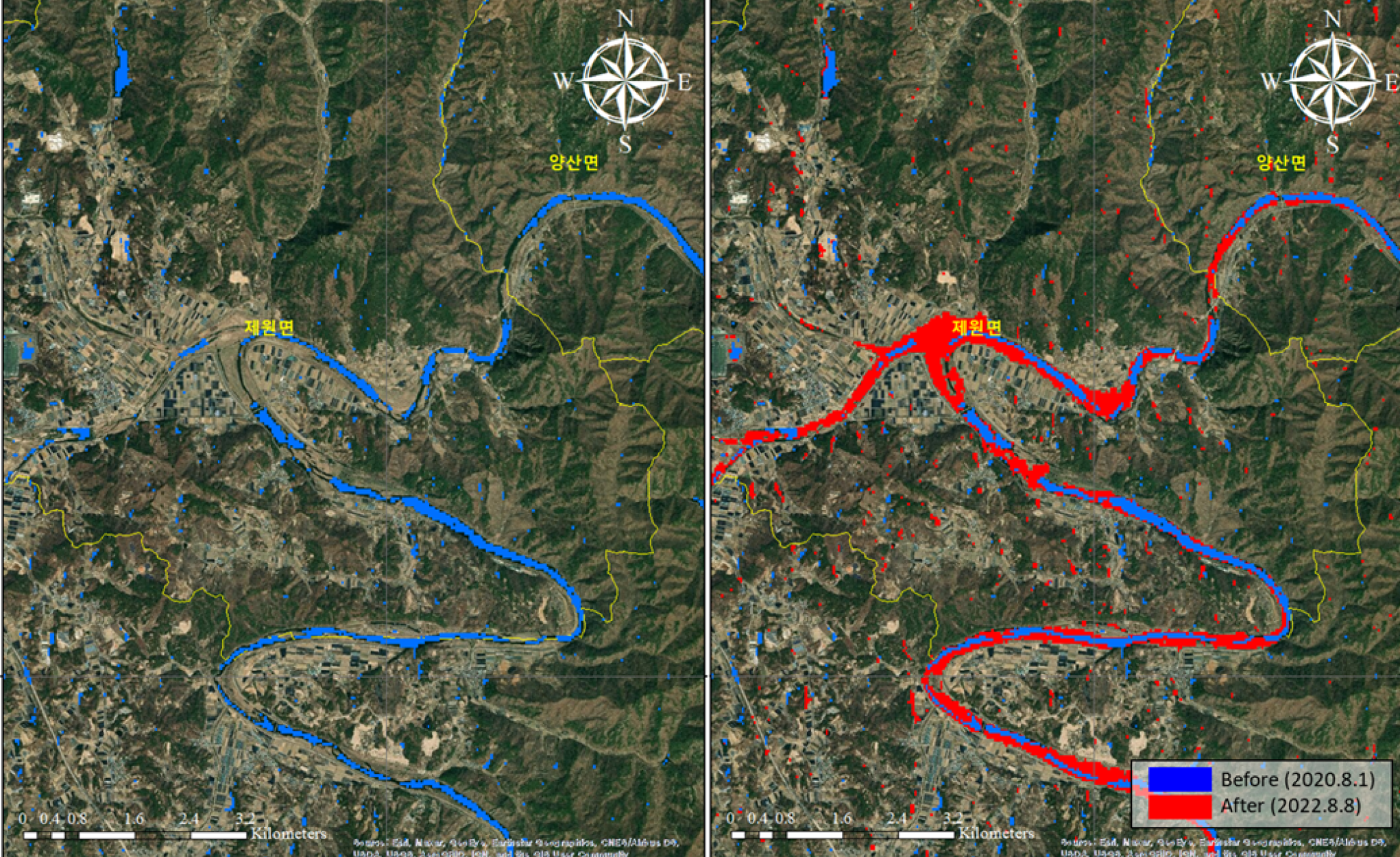
▲ Satellite-based detection of water bodies and analysis of flood-affected areas
Cooperation with the German Aerospace Center for Technology Upgrades
Korea buys satellite images from the US and Finland for use as an additional tool for coping with floods. Still, the focus of those images is not the Korean Peninsula, making it difficult to monitor target areas when necessary. Once the water resources management satellite is launched, we can easily monitor a broad area and directly obtain high-resolution images. As a result, it helps monitor floods more accurately and issue warnings 6 hours in advance to prepare for upcoming floods and minimize damages. Furthermore, the satellite allows us to predict topographic changes caused by floods and calculate the underground water content in real time, enabling identifying risks accurately and taking the necessary and timely actions including evacuation orders.
K-water is also expanding international technological cooperation to ensure the successful development of the satellite and build a solid foundation for its smooth operation. In January, K-water and German Aerospace Center concluded an agreement for the joint development of technology to optimize the quality of SAR images. The German Aerospace Center stands unrivaled in SAR calibration and validation technology. Under the agreement, K-water plans to benefit from its research infrastructure and satellite data, which in turn will enable it to produce top-tier SAR images.
In April, K-water and Institute of Information and Communications Technology Planning and Evaluation (IITP) signed an agreement on the national research project “Ultra-Sall Satellite Imagery-Based Analysis of Key Areas and Reality Intelligence Technology Development” as a step forward in securing ultra-small satellite constellation- and metropolitan area-based water disaster response technology. By doing so, K-water will enhance the quality of data it will obtain from the satellite and conduct precise monitoring almost in real time.
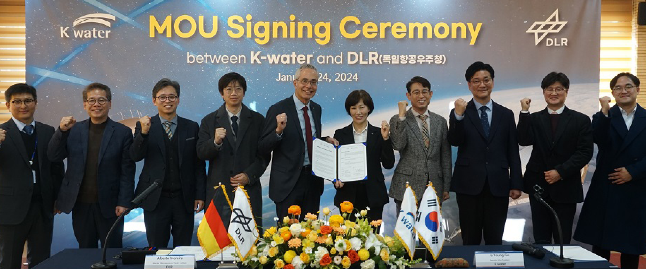
▲ K-water and German Aerospace Center signed an MOU on joint SAR technology development
Securing a Stable Operation Environment is Key
K-water is also working to secure a stable environment for the operation of the satellite. A groundbreaking ceremony was held at the end of 2023 for the establishment of the Water Resource Satellite Center in Sejong Special Self-Governing City, and it is scheduled for completion in the first half of 2025. Concurrently, it is building an integrated satellite operation system to ensure the stable operation of the satellite and collect, process, and distribute satellite data seamlessly. With the satellite in place, K-water will be able to manage water resources more efficiently and protect people better from water disasters. Going forward, it plans to utilize innovative convergence technology fully including water resources, satellites, and ICT and emerge as a global leader in responding to climate crisis, capable of helping countries struggling with a wide range of water problems as well as resolving water issues facing Korea.

▲ Aerial view of the Water Resources Satellite Center


Alberto Moreira, Director, DLR (German Aerospace Center)
Water is a highly important, valuable resource for everyday activities, agriculture, industry, and economic growth. If K-water can monitor, collect, and effectively utilize high-quality data on the entire country regardless of weather conditions through satellite-based remote sensing, its water resources management capacity will greatly improve. I hope the development of the satellite and the establishment of the Water Resources Satellite Center will go smoothly as planned.
Deok-jin Kim, Professor, Seoul National University
Korea is small in terms of land area but maintains a relatively high global profile in the area of satellite and aerospace technology. Once the world’s first water resources management satellite is launched, Korea will be able to respond to climate disasters far more effectively.With the establishment of the Water Resources Satellite Center, I hope K-water will play a leading role in making Korea a global aerospace powerhouse.

Jung-seon Won, Professor, Yonsei University
I would like to commend K-water for its renewed ability to manage water resources more scientifically and effectively than before with the development of the satellite. Southeast Asia suffers from frequent floods and Central Asia depends on mountain glaciers for water supply. If it uses its advanced technology and plays a significant role in helping these regions with their water management, K-water will be able to raise its global profile by a notch as a leading water management company.