-
 2023. Sep VOL. 666
- 2023. Sep VOL. 666
- ENG
-

One of the best ways to enjoy natural landscapes should be “walking”. Some walk into the depth of a landscape, in reflective thought, while others go to clear out their minds. For some, the practice of walking is conducive to having reflective thoughts on philosophical issues. The great thinkers and literary writers, such as the revered seon (or zen) monk Beopjeong, as well as David Le Breton, Henry David Thoreau, and Alain de Botton, have praised the practice of walking.
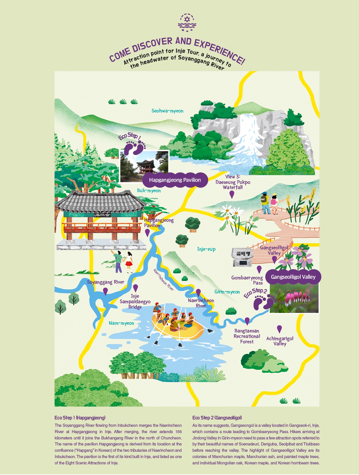
It’s recommended that the best way to enjoy the Soyanggang River to walk around it. Fortunately for foot travelers or hikers, there was a trail created in the vicinity of Hapgangjeong that runs around the upstream of the river. The trail, 23 kilometers long in total, consists of three courses of which the first is divided into Naerin-gil and Haneul-gil. Among the two, the Naerin-gil section starts at Salgumi Village and leads to Chunhyanggol, Seonghwangdang, Jeonmangdae (observatory) and Boteujang (Boaryard) before reaching Soryujeong Pavilion, the terminal of the course. The section is 6.5km in length, which takes about two hours and thirty minutes to completely walk it. The second section Haneul-gil starts at the same point as the first, but turns toward Adeulbawi (“son rock”) at Jeonmangdae, then runs to Chilgongjuteo (“Seven Princesses’ Site”) and Swimteo (“resting place”), and ends at Soryujeong Pavilion. The section is 8.5km long and takes about three hours and thirty minutes to complete the walking which needs crossing a 600-meter-tall mountain.
The second course starts at the Sampaldaegyo Bridge in Inje, located on the 38th parallel north, and after running along the river bank, ends at Soryujeong Pavilion. Starting at Salgumi Park, the third course links Yongbawi Swimteo (“dragon rock rest spot”), Baramgol (“wind valley”) and Byeongpung Pokpo Bawi (“screen waterfall rock”) largely with wooden decks. Soyanggang Trail is easy to walk and has many uphill and downhill sections, providing vantage points for the majestic views of the Soyanggang River. The course also contains a number of prayer stone stacks created by hikers who’ve walked the route.
A walk along the Soyanggang Trail rejuvenates one’s mind and body. The trail is located in the middle of a remote undisturbed part of nature, but has many traces of human existence from long ago, such as prayer stone stacks. The larger part of the trail is overlapped with the paths used by local villagers when they went to the market formed regularly in the village. That is why the hikers taking the trail often feel that they feel a connection with the daily life of the villagers who settled in this remote part of Korea.

It was ten years ago when I last visited Achimgarigol Valley which is nestled between Bangtaesan Mountain, which is famous for the undisturbed natural landscapes. The carefully maintained footpath leads to a trekking course running along the valley which attracts hikers from around the country all year round, especially in summer and autumn. These hikers arriving from around the country to enjoy pristine nature gear up with a pair of hiking poles, and walk up the river flowing through the Achimgarigol Valley.
The Achimgarigol Valley is nestled deep inside nature, encompassed by the towering (1,200 to 1,400 meters) peaks of Guryeongdeokbong and Gachilbong. The remote mountainous area had long been cut off from the outside world until recently when it caught the keen attention of adventurers exploring remote places. The visits by explorers of remote places were followed by ordinary trekkers. Nowadays, the valley can get crowded with hikers arriving from around the country, who are eager to enjoy the beauty and health of nature well preserved as they were a long time ago. The trekking in the area embarks from Galteo Village in Bangdong-ri and ends at Jogyeong Dongbungyo (“Eastern branch school”) of Bangdong Elementary. The straight-line distance from the start to finish is only three kilometers, but the actual walking distance is about seven kilometers as the trailing route follows the bent-shaped valley. The valley waters stay ice cold even on the hottest summer days. The towering skyscrapers in cities emanate heat below the blistering sun, but the pristine forests and the pure ice-old water of Achimgari Valley awaken and rejuvenate hikers’ mind and body for a long time. The path crosses the valley waters and leads to a new walk path.
The road extends into the mountain through a valley, and is a path less traveled. Birds begin to sing at the same time as the wind blows. The road becomes increasingly dimmer before disappearing completely. It’s clear there is no other choice but to walk down to the valley and keep on walking. A walk through the valley leads pedestrians to a dense forest of larches. Taking a stroll between the tall larches towering above will make a person whistle his favorite tunes. The trail then disappears again after the larch forest, and it then dawns on the pedestrian that in Achimgari Valley there are no paved roads. The paths found here are only those allowed by a celestial being or created by the water flowing through the valley from its head fountain located high up the valley.
The pedestrian now arrives at an open area of flat rocks with a series of cascades and basins of different sizes. The surrounding rocks now change their color from black to white and the valley containing them now bends to reveal white sandbanks, inviting him to have a seat and take a rest on them with the stunningly beautiful landscapes to enjoy.
A three-hour walk through Achimgari Valley leads to an open space, revealing that the blessed scenic sites of the valley are coming to an end. It is now the time for him to make a decision about the best route to take. He can either proceed to Bangdong Yaksu Springs taking an unpaved path, or continue to walk upwards through the valley until reaching Woldun of Nae-myeon, Hongcheon-gun.
Gombaeryeong is the name of the pass located about 1,100 meters above sea level, providing a passage linking Seolpibat Village of Jindong-ri, Inje-gun with Gombaegol of Gwisun-ri. In August, the area around Gombaeryeong Pass turns into a lovely botanical garden filled with various wild flowers, and maintains the picturesque scenery until the onset of winter. The trail leading to the pass starts at the valley called Gangseolligol located in Gangseon-ri, Inje, and offers a comfortable hiking trail even for children to do. Hikers on the trail come upon a small stream with stepping stones crossing it about 30 minutes after departing from the starting point and passing by the stream, a dense pristine forest inhabited by a variety of shade plants, including fern species.
The trail to Gombaeryeong Pass begins to steepen at 300 meters ahead of the summit of the mountain pass, although the incline is not too steep to handle. After about one and half hours after hikers leave the starting point, the dense wood suddenly disappears with an open space unfolding before their eyes, and find themselves standing on the ridge.
It is estimated that about 850 to 950 plant species in all grow naturally along Gombaeryeong Pass and Jeombongsan Mountain. This figure accounts for 20 to 30% of every plant species known to exist in South Korea. The well-preserved ecology of Jeombongsan Mountain is attributed in part to the healthy soil, in addition to the absence of major wildfires there for the last 300 to 400 years. On the ridge of Gombaeryeong are sculptures of a pair of animals. Reaching the summit of the pass, hikers need to take one of two paths to proceed on their journey, with one running northward to the left, interlinking Jeombongsan Mountain with Baekdudaegan, a huge range of mountains forming the backbone of the Korean Peninsula, and the other running southward to the left to Horangi Koppaegi (“tiger’s nose”), Gacheolbong Peak, and finally Naerincheon River.
Could there even be such a wonderful garden in another part of the world? It’s a wonder how such a large colony of vibrant wild flowers flourished on a mountain ridge such as Gombaeryeong. The ridge is a large grassland without a single tree, because wind blowing over this part of the mountain is too intense to allow anything to stand firm. The wind may have always been strong, but could not keep the wild flowers from taking root and growing against it.


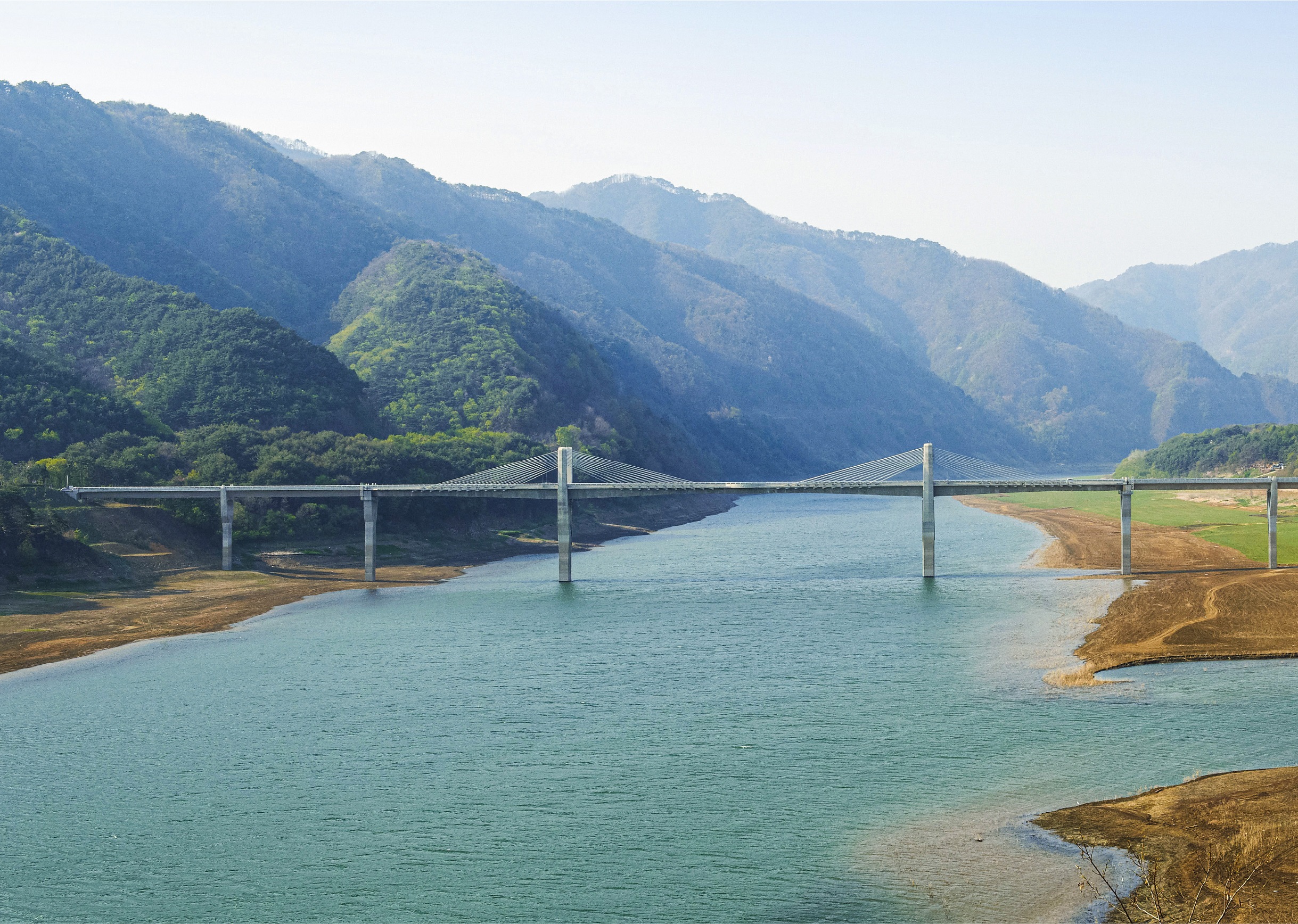
The name of the river, Soyanggang, reminds many citizens of Chuncheon city, the administrative center in the area around the river, but its headwaters and most of its upstream section is in Inje, Gangwon-do. The upstream section of the river is famous for a trail running along its banks, where its natural surroundings have been kept in pristine condition. The Soyanggang Trail was officially recognized as a national forest trail through a contest organized by the Ministry of Public Administration and Security. The trail consists of three courses, the first of which is 8.5km-long Haneul-gil, the second is 2.1km-long Naerin-gil, and the third is 4.9km-long Soyanggangbyeon-gil.
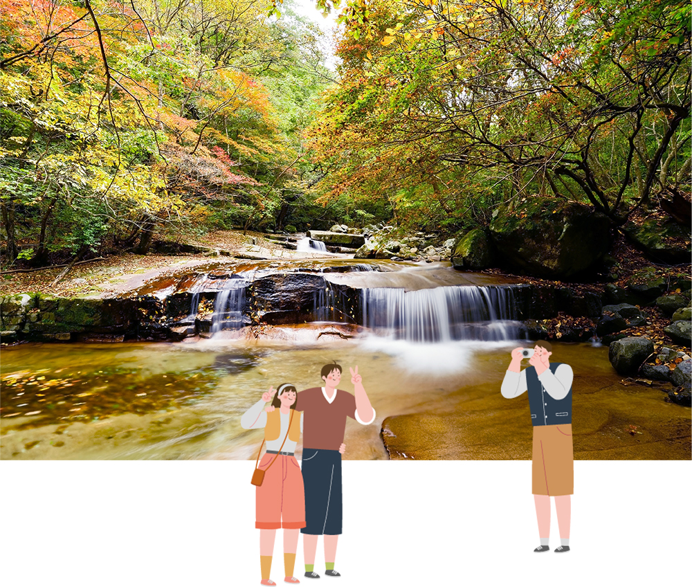
It is generally agreed that Bangtaesan Mountain in Inje contains one of the most beautiful temperate deciduous forests in South Korea. The forest is dense with sawtooth oak, Korean hornbeam, painted maple, Korean elm, and maple trees. The trail along the valley leads pedestrians to a large flat rock creating a large open space and later a two-tier waterfall called ‘Ipokpo’ and ‘Jeopokpo’. The waterfall rises up 10 meters high.
Address: 377 Bangtaesan-gil, Girin-myeon, Inje-gun, Gangwon